The planet of Mars seems to be littered with all kinds of features that seem to so clearly demonstrate the once presence of life, or even that life still remains. Pretty much all of this very interesting information is seldom mentioned with in mainstream. All the images used here are have been originally obtained from NASA or ESA(European Space Agency) and edited by people with lines to mark the specific angles or filters to provide a clearer view of the surface details, none of them have had anything new added to the actual picture.

There has been an enormous amount of research done on this area called Cydonia, a great deal of it has been conducted by the Enterprise Mission, lead by Richard C Hoagland. The angles and measurements with which the landscape is alighned to is exactly correlated with sacred geometry, much like many ancient monument sites we have here on Earth, such as the Great Pyrimids or Avbury.

 |
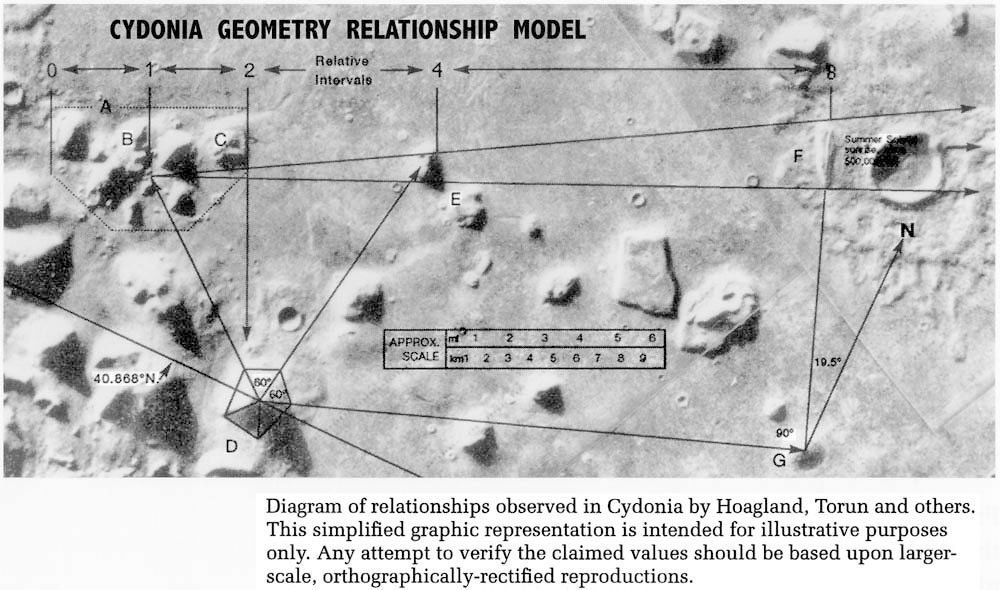
The Cydonian Golden Mean Diagram shows the advanced artistic, mathematic and geometric implimentation of the Golden Means within the arrangements of The Face, Pyramids, City and overall design of the Cydonia Complex. Cydonia shares this trait in common only with known artificial structures, that were designed by mysterious civilizations in antiquity. This is a signature, a fingerprint, of a vastly advanced scientific culture - and one that we have no public record of.

Smaller Mounds in the Complex Arranged with Sacred Geometry
Analysis of the positions of various smaller mounds within The City shows their geometrical relationships based on universal constants.
The position of mound D marks the center of a side of a tetrahedron.

The smaller pyramids form these angles which are signature of ancient monuments here on Earth.
 |
From the D&M Pyramid to the face is exactly 1/360th the polar diameter of Mars. The polar diameter of a planet is the distance in a straight line ground through the center of the planet between the two north and south poles. Think it's random chance that a pentagonal shape, near impossible in natural landscape is this exact distance from a rock that highly resembles a face then those two with another near impossible natural formation of pyramids made a perfect 19.5(a prime sacred geometry angle) angle?
There is a very obvious connection between Avebury located north of Stone Henge and Cydonia. When Cydonia is reduced to a 14:1 mile ratio key structures are complete mirrors of the ones built in Avebury.

Shown above, the Avebury circle is the largest of all stone circles on earth, it is incredibly complex with all sorts of astrological alignments and measures a quarter of a mile across. About 4 million cubic feet of material was excavated in order to construct it. The creation date is unknown of this mysterious complex but it definetly goes back thousands of years. Another interesting fact is this area is one of the most popular crop circle locations on the entire planet.

Silbury hill, built is a spiraling formation that twirls at the same ratio and in the same direction of the Cydonia spiral


Cydonia with map of Avebury Overlayed
Silbury Hill is aligned perfectly with Spiral Mound on Mars
The large crater on Mars is superimposed over The Outer Circle of Avebury
The peak of the five-sided DM Pyramid corresponds to the The Stele.

The four roads in the Avebury complex all form tangents with the most significant features of the Cydonia complex – as well as the Avebury landscape. The roads tangent (pass to the side of) the south of the spiral mound/Silbury Hill, to the southern rim of the Cydonia crater/Avebury circle, the south-east corner of the five-sided pyramid and to the north-east corner of the location of the 'city'.
The Face was place intelligently.

The angles of a tetrahedron, 720° x 2 = 1440 multiplied by Pi, the universal constant, extends to 4523.893421, thereby encoding 41° 11’ 10.03080581" which is the precise latitude of the 'face' on Mars.
This can be verified by taking the given latitude and multiplying the numbers with each other. 41 x 11 x 10.03080581 = 4523.893421.
Elysium Quadrangle
In 1972, Mariner 9 took literally thousands of historic first photographs of some very interesting features on the surface of Mars, that perhaps are now taken for granted. Besides discovering that Mars once had water very much like Earth (evident in dried up riverbeds), the largest yet known volcanoes in the solar system (the Olympus Mons family of giant molehills), and Valles Marineris (which is named after the probe and makes the Grand Canyon look like a pot hole); it snapped another extremely important, ancient archaeological site on Mars, at 15°N latitude (and 198° W longitude) - known as the Elysium Quadrangle.

This is a zoomed in version of the original photo showing certainly aligned tetredron or 3 sided pyramids, they are each around a kiliometer high, being 10 times higher and 1000 times the volume of the Giza pyramids. Two important Mariner 9 images, MTVS 4205 (taken on February 8, 1972) and MTVS 4296 (taken on Aug 7, 1972), taken at different angles of the sun, plainly show that the structures are not random formations or illusions of surface coloration.The subject was immediatly dropped when the scientists could not prove they were natrually occuring.


At this link here: Buried Ancient Martian City Scapes You can find more pictures such as these few below. They are made by Enterprise Mission and they are from unchanged images that are put under inferred filters to reveal substructures. Right rangles rarely occur in nature and not ever do they do so to the magnitude you see here. Richard Hoagland, who I find to be quite established as a good source is very positive these are buried cities.


Is NASA hiding something on Mars?


Current Life on Mars?
I think the images above already display more then enough evidence to be certain that there at least was at one time life existing on Mars and that it has connections with Earth. However there is still more very questionable data, some of which could hold a strong indication of life still presently on Mars. All this again, is coming directly from NASA and ESA image databases.
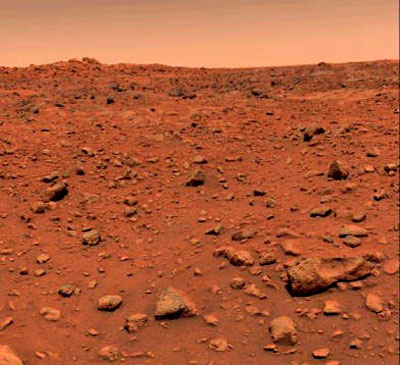
Here is a panoramic picture from one of the Mars rovers, looking to the left of the picture you may notice something a little bit out of place.

Yeah.. I'm pretty sure that is a piece of wood.


No comments:
Post a Comment